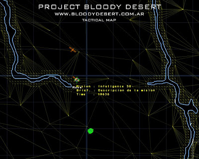
Despite that the scenary is not finished yet, I decided to create a system in which the map generates itself according to the mesh of the scenary, this way I avoid to create a new map each time I change something in the scenary.
I would love to have a geographical style map, but that’s gonna have to wait, instead this new map contains lines and colors according the points of latitude, and a little transparency, so it won't mix up the map with the units.
This tactical map shows us an icon that represents each unit and its orientation, except in the case of the soldiers.
I’m also creating a new system to generate missions. These missions will be seen in the tactical map, with an icon of a satellite, and we can choose to accept the mission or not, and try to accomplish that mission. If we don’t accept the mission, and we let it pass, new missions we’ll be generated.
As you can see now the web site in both versions, Spanish and English. Also is available the new forum. So, please visit us at http://www.bloodydesert.com.ar and registrate. If you’d like to help, we’d like to have ideas from you.
New 4 x 4 civil trucks
Here is a new truck for one of the bands, I hope you like it. Some features are:
4 x 4 civil armed truck
2 crew
2 passengers max.
cannon
Poor blindage
Good speed

To add some realism to the scenario, I’m modeling some vegetation. Here the first shoot, I think it went just fine. I’ll try to make a (desert) vegetation generator.
